

Altitude Aerial Media
Photogrammetry, LiDAR, and Inspections
Trusted by Florida surveyors, engineering firms and construction teams


Professional Aerial Mapping and Inspections
LiDAR Mapping
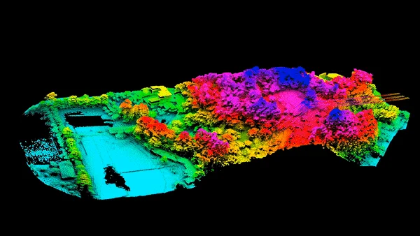
High detail point clouds, bare earth contours, DTMs, DSMs and CAD ready deliverables
Photogrammetry

Survey-grade orthomosaics, contours, elevation models and CAD ready deliverables
Aerial Inspections

Roof, facade, solar and telecommunications inspections with high resolution and actionable insights
Thermal Inspections

Thermal scans for moisture mapping, solar panel hot spots and industrial/infrastructure diagnostics
Why Choose Altitude Aerial?
-
Your projects - our expertise
-
Quick deployment for projects
-
Save time and money with fast data collection
-
Expand your team and cut your expenses
-
Accurate and reliable deliverables
-
We handle aerial regulations and laws
-
Fully insured

Florida Drone Expertise
Altitude Aerial is fully compliant with FAA standards and keeps safety and regulatory compliance as our top priority for every job, every time.
Our solutions are tailored to your specific projects and needs. We take the time to understand your concerns, needs, and desired results. We bring our unique capabilities alongside your workflow to increase your productivity and safety, while decreasing your time on site.
Industries We Serve
Surveying
Construction
Engineering
Mining
Landfill Management
Wetland Consultants
Solar Industry
Get in Touch!
Reach out to us! We're happy to answer any questions you might have!
Phone: (863) 234-6588